
 My feet kept sliding backwards, it was clear I had taken the wrong path in my trek to the summit of the Cavehill in the Cavehill Country Park. It dawned on me that this was probably why the sign said the equivalent of 'take the sheep's path at your own risk'. It really hadn't looked this steep from the bottom. Oops.
I caught my footing and clambered back to much sturdier ground that was scattered with plenty of fixed-in-place rocks. I negotiated my way over them, on all fours at times. It was like being a kid on a climbing frame again.
 Conscious of eroding the hill quicker than nature and other people were already doing, I did my best to not cause the scree I was walking on to relocate further down the slope. I dodged the rabbit droppings that were peppering the ground and after a quick stop to rabbit spot, I was all but a short climb of some steps from McArt's Fort.
Before we head up those stairs though, here is where it all started...
The Monday before last was the Monday following the weekend of joy that crescendoed with Leeds United being promoted from League One to the Championship. So whilst feeling on top of the world, I had planned to use one of my days off to head a little higher in the physical sense of the term. So when the weather forecast had given the indication that Monday was the best day of the week to be heading outdoors, I made a vague plan. The idea was to make my way to ASDA on the Shore Road, to buy some supplies and then set off walking towards the Cavehill Country Park and, via Belfast Castle, make my way to the top of the Cavehill where I would reward myself with my lunch.
I know Divis at 478m is the highest elevation of Belfast's Hills but at 370m the Cavehill won out, mainly because it was closer and I couldn't fathom how to make it to the top of the Divis hills with just public transport and my own two feet (at least in any reasonable length of time) - though having found the link there I think that this trip might be do-able in the future!
Kitted out in the sort of gear you'd wear to play 5-a-side football but with a coat over the top, I beeped my items through the self-service checkouts and started my walk.
From ASDA this was my eventual route:

The first part was a breeze. It began well as I hadn't even passed too far by the old gateway to the Fortwilliam area before I had spotted some wildlife. It was a grey squirrel foraging around but it was already on the move before I had the sense to try and take out my camera. I was soon at the Antrim Road and walking up Innisfayle Park and into the grounds of the park.
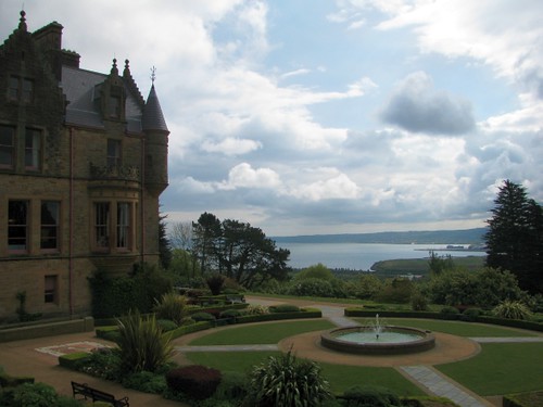
The incline started to pick up as I approached Belfast Castle itself. Belfast Castle is a castle only in the palace type definition of the word as it is a sort of Victorian stately home, but is never the less an impressive structure with quite a view.
Having found myself here plenty of times before, I didn't go snooping around and just passed through the gates to head onto the forest path. The path leads up to an odd feature of the Cavehill, a depression surrounded by tiny-hillock like mounds and boulders, an area known locally as the 'Devils Punchbowl'. The path is lined with trees and from a gentle start gets quite steep about 3/4 of the way up to the Punchbowl. Being unfit and wanting to make it to the top as soon as possible (I was very hungry by this point) I took a quick rest and took on some fluids to keep me going.
 I set off again and soon made it to the Devils Punchbowl. Once there I had a look at the quickest route to the top. I was in two minds as to whether to stick with my original plan of making the steepish clamber or take the easy but longer hike. Sat on the edge of a hillock looking up at the hill I made my mind up. Or was there a little devil on my shoulder telling me to do it? Whatever the real reason, I decided I was going to head up the steep route.
With slightly heavy legs I began the walking-clamber. At first it is a slight hill heading south beneath the cliffs, then with the large basaltic outcrop looming, the path became earth and rocky scree. With the path uneven and very loose in places I was in two minds between looking up incase of falling rocks and looking down to ensure I wasn't going to be heading backwards.
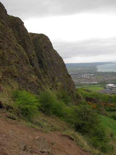 Inbetween the glances up and down I caught sight of something moving. Two rabbits bounded in opposite directions and out of site. Like Alice spotting a glimps of the white rabbit, I had to follow, although unlike Alice, I had a camera with a decent zoom so didn't have to get too close. Having spotted a rabbit moving I had the camera on and aimed. But where had it gone? I never saw it leave. I took a photo and had a look. Still nothing, but...ah wait, there it was! It was camouflaged against its habitat, presumably to make it harder for the birds of prey that stalk the hills to make the wee thing their next meal.
Back on the move, I found myself facing a literal uphill struggle. I could perhaps make better progress on a solid base of rocks. With that plan though came the problem of it being steeper. I ended up having to use my hands as well as my feet. It was feeling like the wrong choice, but in so many other ways it was the right choice. I was feeling free and having fun, even if I was having to avoid putting my hands in rabbit droppings.
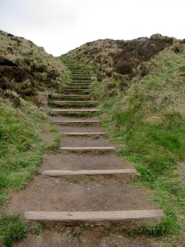
I persisted and only got myself in a twist the once which required sitting down and spinning around. Having got out of that pickle I was soon on a short walk on flatter ground between two outcrops feeling quite proud of myself. I was near the top but couldn't yet see anything infront of me but rock, grass and path. The informal path reached a proper one and a cattle gate too. I was almost at the top, a climb of the steps away from the view from McArt's Fort.
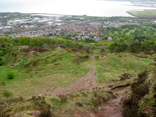
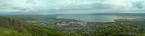
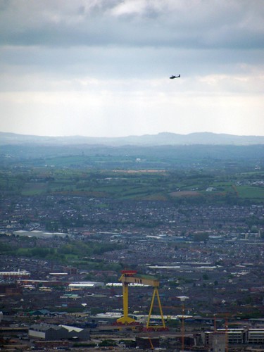
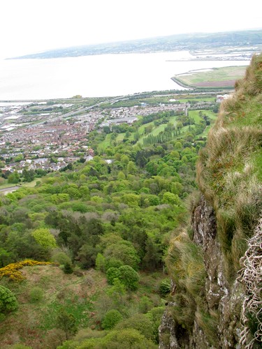
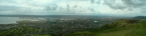
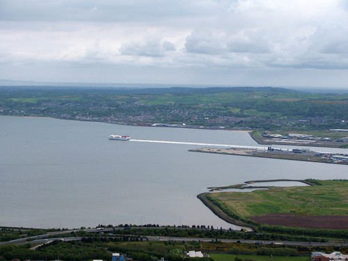
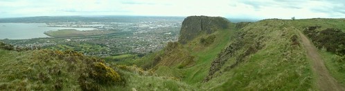
As I made my way up the steps, the anticipated panorama was hesitant in appearing and a continued view of grass meeting the sky met my eyes. Then there it was, Belfast and the surrounding area, in the distance I could see the North Down coast and further afield. The Mourne Mountains were poking in and out of the clouds and the city was bustling by below me.

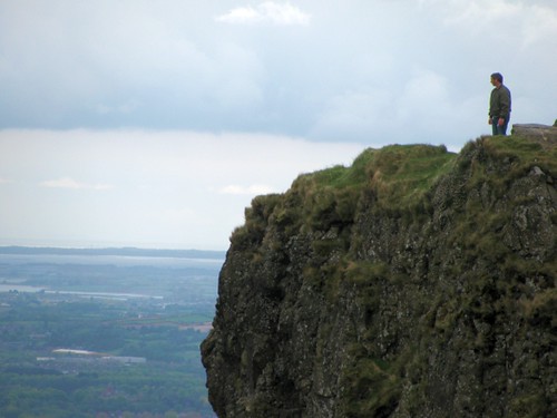
Sadly there was quite a bit of cloud so the view from the top of the Cavehill wasn't quite as far reaching as it could have been, but it was quite a sight never the less and here are some of the sights I captured on camera from (and in one case hanging over) the edge of Napoleon's Nose:
Once I'd absorbed the view, I sat myself down and unzipped my backpack. I took out the goodies I had bought and dug in.
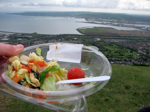
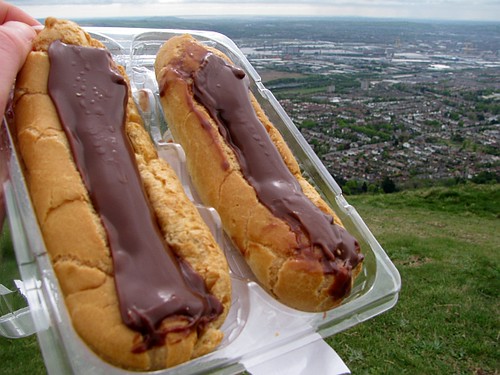
Settled down for a short stay, as you do. I set up a windmill and with the wind up there it spun like it had never spun before (yes I am a big kid, did I not mention that already?). Also except from birds, planes or the wind blowing it off the cliff, I was protected on all sides from food thieves and could really enjoy the hour or so I loitered watching the world go by.
Reluctantly, I had to make a move and head down the hill. I packed up my things, making sure not to leave any trace of my presence. The question in my head was then, which way?
After hopefully joining me in a short hypnotic interval with the Hypnowheel of Belfast, please do visit the next page - Part 2 of Exploring the Cavehill and Cavehill Country Park to find out what I came across next.
Awesome pictures!! I can't wait for part 2!
ReplyDelete